Transportation Environmental Study Report (TESR) is available for a 30-day public review period.
The report documents the environmental assessment process, described the preferred design, and outlines the environmental protection measures that will be put in place. Public comments are welcome during the review period.

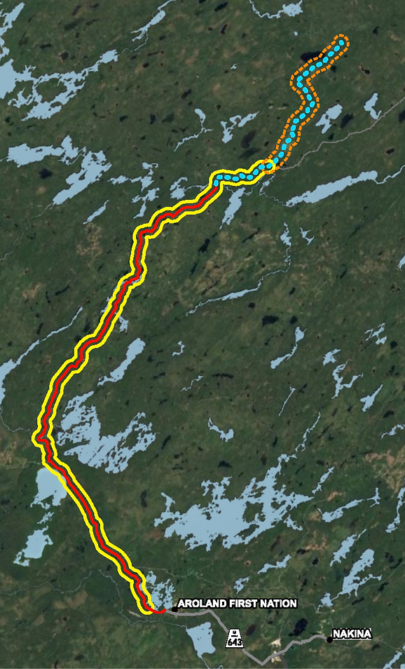
The project is located in Northwestern Ontario, north of Aroland First Nation. The study area begins at the end of Highway 643 and continues north to the end of Painter Lake Road. Along the way, the road crosses several rivers and lakes, including the Kowashkagama River, Terrier Lake, Kapikotongwa River, Colpitts Creek, and other smaller tributaries.
History of Anaconda Road and Painter Lake Road
Anaconda and Painter Lake roads are currently forest access roads located on Crown land which have been in use since the 1950s. Until 1970, the lower part of Anaconda Road was a private road. In 1977, the MTO designated Anaconda Road as an industrial road, under an agreement with Kimberly-Clark, Dominion Foundries and Steel Limited. The goal of designating the road was to develop the forestry, pulp and paper, and mining industries. The agreement ended in 2002 but the road remains designated as an industrial road under the Public Transportation and Highway Improvement Act.
Currently, the forest access roads are operated and maintained year-round primarily by forest resource license holders. Other uses of these roads include local travel, recreation, tourism, and access to Indigenous communities. These roads provide the only connection between Highway 643 near Aroland First Nation to the Marten Falls First Nation winter road.
Access is controlled by the Ministry of Natural Resources (MNR), an access control sign is located at Terrier Lake on Anaconda Road. Access is restricted to reduce public access to remote tourism lakes; however, Indigenous community and industrial use of the road is not restricted. The planned upgrades will not change the access restrictions.
Regional Setting
The project is in the Thunder Bay District within Geraldton-Nipigon MNR district.

Study Area
The project extends from the end of Highway 643, near Aroland First Nation, northerly along Anaconda Road for 69 kilometres, continuous onto Painter Lake Road.
Part A of the project is outlined in solid yellow line, which includes Anaconda Road shown in a red solid line, and eight kilometres of Painter Lake Road shown as a blue dashed line.
Part B, which includes the remainder of Painter Lake Road, is identified with an orange dashed outline.